Blog

Charles H. Baker: Land Investor of the Palatine Hills plat in Fremont

The Fremont neighborhood has a lively history which parallels the story of the City of Seattle’s growth and development.  Just as in the beginnings of Seattle in what is now downtown, the earliest white settlers of Fremont were attracted by the availability of natural resources, most importantly water and timber. As Seattle grew, land investors hoped that a railroad would come through their property, which would increase the value.

Located just to the northwest of Lake Union, Fremont was on the banks of a stream which at first was called The Outlet, flowing westward through today’s Ballard and then out to Puget Sound.  The Outlet was also called Ross Creek and it was used to float logs to mill.  Eventually the creek became part of the route of today’s Lake Washington Ship Canal.

Charles H. Baker came to Seattle in 1887 as a single man determined to make his fortune and establish himself so that he could get married.  He worked as a surveyor for Seattle’s homegrown railroad corporation, the Seattle, Lake Shore & Eastern.

The survey work brought Charles Baker into contact with Seattle’s movers and shakers including Judge Thomas Burke, Edward C. Kilbourne and William D. Wood, and Baker’s name is seen on land investments with these men, including plats in Fremont and plats in the Wedgwood neighborhood in northeast Seattle.

Charles Baker lived in Seattle for about fifteen years.  During his time in Seattle his land investments failed partly because of the economic depression which began in the year 1893.  Another reason why his investments failed was because they were in lands which were slow to develop, such as today’s Wedgwood neighborhood, which was too far from downtown Seattle to be convenient. Baker platted sections of land for house lots in today’s Wedgwood which did not sell, as the area had no infrastructure such as roads or utilities.

In the 1890s Charles Baker built the power plant at Snoqualmie Falls, only to lose ownership of it when his father died, because of legal issues.  In 1904 Baker gave up on Seattle and moved to Florida.  Even though the Snoqualmie Falls power plant which Baker built continues to supply electricity to Seattle today, few people are aware that it was Charles Baker who made this essential contribution to Seattle.

One of Charles Baker’s early investments (1888) was a plat of land at a high point in western Fremont at N. 43rd Street, which he named Palatine Hill.  The name came from Baker’s home in a suburb of Chicago, Illinois.

In later years the streets in the plat had to be renamed for clarity, to eliminate duplicate street names around Seattle. The name Palatine Avenue was used for the former Adams Court (on the far right on the plat map.)  On the left side of the plat map, Crawford shows the boundary with the Crawford family property, which became 3rd Ave NW.

One avenue formerly called Peck was later renamed Baker Ave NW between 2nd Ave NW (Harmon) and 3rd Ave NW (Crawford.)  Chicago Street is now 1st Ave NW.  What was designated as Palatine on the original plat map, is now called NW 43rd Street.  Some of these street name changes reflect Seattle’s 1895 ordinance to reorganize the street naming system.  It was required that north-south routes be called avenues, and east-west was called a street.  That is why plats earlier than the 1895 ordinance, like Baker’s Palatine Hill plat of 1888, have had name changes.  Plats filed from 1895 onward, had to conform to the street system of Seattle and have unique names for their streets, not re-using common names such as Broadway.

For further info:

Fremont in Seattle: Street Names and Neighborhood Boundaries.

Sorting Out Seattle Street Names.

Street Names North of Lake Union.

The Ross and Fremont Post Offices

Some Seattle-area neighborhoods, like Bothell, were named for early settlers.  With the arrival of the Seattle, Lake Shore & Eastern Railroad in 1887, a railway station could give its name to the neighborhood. 

Just north of Seattle’s Queen Anne hill, the Ross family had land claims on both sides of a stream called The Outlet, which flowed from Lake Union westward out to Puget Sound.  The Ross family gave permission for the new railroad to come across their property and the railroad planners named a station in their honor.  This caused the area to acquire “Ross” as a place name. 

Ross was to the west of Fremont, bordered by 3rd Ave NW, and it included land on the south side of today’s ship canal.  The earliest listings of “Seattle Seminary” (today’s Seattle Pacific University) in the City Directory of the 1890s gave its location as “Ross.”  This also had to do with an actual post office for Ross, so that people could list it as their address.  

The Ross Post Office opens in 1888 

The coming of the SLS&E Railroad gave rise to more commercial development wherever a railway station was built.  There was a general store and a Ross Post Office which opened on July 30, 1888, at 318 Ewing Street, on the south side of The Outlet. Today that address is on the west side of a canalside pocket park, near the present King County Wastewater building. 

The first postmaster of Ross was Alfred J. Villars who had been born in 1843 in Clinton County, Ohio, and had served in the Union Army during the Civil War.  As typical of many Civil War veterans, Alfred Villars married in 1865 after the war, and then the couple gradually moved westward across the USA.  In 1888 Alfred & Harriet were listed in the Seattle City Directory as living in Ross where Alfred was postmaster.  We know, however, that Harriet might have been the “default postmaster” because Alfred had another job.  Perhaps this arrangement was not satisfactory, as another postmaster took over by the end of 1888.

Alfred Villars was a “title abstractor,” someone who researches property ownership so that sales of land can proceed without legal hang-ups.  A title search ensures that there are no outstanding “encumbrances” such as liens against the property.  This work would have meant that Alfred spent most of his time in the King County courthouse in downtown Seattle where records where kept.  

In 1897 the Villars moved away from Ross when Alfred got a job at the downtown Seattle Public Library, where he worked for the next 23 years in the library’s “newspaper room.”  In those days before radio, TV and the Internet, newspapers were vital sources of information.  Newspapers were made available at the Seattle Public Library so that people could read them without a subscription.  

The Ross Post Office closed in 1901.  In 1902 the building at 318 Ewing was referred to as Old Post Office, in a list of polling places for elections. 

Growth of Fremont outstrips Ross 

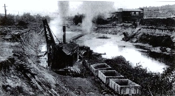
Although both communities had a railroad stop, in the summer of 1888 the growth of Ross was eclipsed by that of Fremont.  Fremont’s developers set up a lumber mill to help provide for housebuilding, and they advertised that the first hundred people to come to Fremont could buy a house lot for $1.  Fremont, centered around today’s North 34th Street & Fremont Avenue where there was already a bridge across The Outlet, soon boomed with commercial and industrial growth.  In contrast with Ross which was not a planned community, Fremont had developers who planned and organized for growth, including promotion of Fremont in real estate ads in the newspaper.  

The Fremont Post Office opens in 1890   

Fremont’s post office opened on March 25, 1890.  Like the Ross Post Office, at first it operated out of a home on the south side of the existing Fremont Bridge, probably to get clear of the frenzy of building and lumber mill work on the north side of the bridge. 

The first postmaster of Fremont was Thomas C. Ralston, someone who had only arrived in Seattle in 1888.  He joined those going to Fremont for jobs in that first year of the community.  Though he obtained the job of postmaster, it is likely that his wife Ida was the one who was doing that work from their home, while Thomas worked at the lumber mill in Fremont. 

Death of the postmaster

Thomas Ralston’s term as Fremont postmaster was brief.  At age 37 on August 11, 1892, Thomas received a fatal injury while he was unloading logs from rail cars, using a chute to let the logs slide down into the water, at the site of the Fremont lumber mill.  The King County Death Register recorded that Thomas had been struck by a log so that he had an internal hemorrhage (bleeding). 

A Ralston family letter of August 23, 1892, tells that they had heard from Sylvester “Sil” Ralston, brother of Thomas, what had happened to Tom: 
“. . .You ask me if I had heard any more from Sil and if Tom was in Washington yet. Poor man. He is there but under the sod. He was killed the 11th day of this month while unloading logs out of rail cars into the lake. He had unloaded one car… the logs begun to roll down the chute and one of them struck him in the breast and knocked him into the water. There was but one man there with him. He was a car repairer. He got Tom out on the bank and asked him if he was badly hurt and if he should go to get some help.  Tom said, I’ll be all right in a minute. The man soon asked him again and Tom made the same reply, but he then closed his eyes in unconsciousness.  The man laid Tom back on the ground and went for help.  

They took Tom home. The doctor said several ribs were broken, and Tom soon breathed his last. They put a subscription in circulation and realized $102.25. It took $75.00 to pay funeral expenses and the rest was given to his wife Ida. They had a petition going around asking that she be appointed postmistress in his place. It was being signed wherever it went.”     

For the next year and a half, Ida Ralston was listed as postmistress at Fremont but it is likely that there was not enough income for her to support her family.  She was now a widow with four daughters under nine years of age.  In 1894 Ida moved to downtown Seattle where she successfully ran a lodging house. 

Neighborhood names 

At times when there were gaps of service of postmasters, mail for Fremont was directed to the post office of a neighboring community such as Ross or Edgewater.  There was no home delivery of mail; people had to go to the post office to pick up letters.  Newspapers often ran lists of names of people to let them know a letter was waiting for them.   

Edgewater’s post office opened on May 20, 1889. The postmaster was William Ashworth who lived at the present site of the North Transfer Station, on North 34th Street just east of Stone Way.  Like Ross, Edgewater was a railroad stop and a name for a community.  These names didn’t “stick.” Today the former Ross area is referred to as North Queen Anne.  The ship canal, completed in 1917, changed the landscape so that Fremont was defined as on the north side of the canal only. 

The community names of Edgewater and Latona faded away as the name Wallingford gained in common use. Today Stone Way is considered to be the boundary between Fremont and Wallingford.  Now the closest post office which serves the Fremont area is in Wallingford on North 47th Street just east of Stone Way. 

Sources: 

Fremont in Seattle: Street Names and Neighborhood Boundaries.

HistoryLink Essay #494, “Ross Post Office opens on July 30, 1888”, by Greg Lange, 1998.

HistoryLink Essay #508, “Fremont Post Office opens on March 25, 1890”, by Greg Lange, 1998.

Ross School in Fremont.

Street names lookup list: Seattle historian Rob Ketcherside has listed old and new street names in a search table. Most of the street names in Fremont were changed over time. Fremont Avenue, for example, was once called Lake. It was changed because more than one neighborhood was using that name. Beginning in 1895 the City of Seattle tried to rename streets for clarity and so that there would not be duplicate names.

Plats of Fremont

One of the ways to trace neighborhood history is by its land use, including plats of land laid out with streets and house lots. This map of the Fremont neighborhood in Seattle is marked with plats and their names.

The founding of Fremont in 1888 was in the area closest to the ship canal, although at that time it was only a small stream called The Outlet. The plat, which was named Denny & Hoyt’s, was on both sides of the stream, as far south as Florentia Street and to the north, at 39th Street, marked in light yellow on this map. A “plat” is a map of streets and house lots within the borders of a land claim. Plats have names, and the list is shown here, of the plats in Fremont.

Fremont’s original founders bought about 212 acres which had been the homestead land claim of early Seattleite William Strickler. Strickler disappeared in 1861 and the issue of who would come into ownership of his land, was not settled until 1887. Finally, Seattle investors Denny & Hoyt were able to buy this property. They soon re-sold it to the Blewetts, investors who came from Fremont, Nebraska. The Blewetts kept the original plat name which is the large section shown in light yellow on the plat map. Fremont was outside of the Seattle City Limits at that time, so it was founded with its own name, like a suburb.

Over time, many other investors bought sections of land, represented by the different colors in this map. Some investors lived in Fremont themselves, such as Sidney S. Elder, a former pharmacist, who transitioned into real estate work. He named his plat the S.S. Elder’s Orchard Addition. Another Fremont resident was a Civil War veteran, George Boman. His plat of land was named Edgemont to give tribute to Fremont + Edgewater plats nearby, on the eastern edge of the neighborhood near Stone Way.

The red-colored plat in the center of the map is that of B.F. Day, a real estate investor who donated the land for Fremont’s B.F. Day Elementary School. Mr. & Mrs. Day lived nearby and were active in Fremont beginning in the 1880s. When the Days filed their plat, it was technically outside of the original Fremont area, bordering it at North 39th Street. The map here, shows our present-day perception of the Fremont neighborhood which is now considered to have its northern border at North 50th Street.

Directly above B.F. Day’s plat is Sunset Heights (blue slash lines). This plat, filed by two Norwegian immigrant couples, tells the story of life in Seattle in the 1880s-1890s. These landowners did not live in the plat themselves but hoped to derive income from lot sales.

Fremont Public Art: Late for the Interurban

East of the Fremont Bridge on North 34th Street, near Adobe Plaza, Seattle’s favorite clown, JP Patches, and his friend, Gertrude, are forever “Late for the Interurban” in these bronze statues created by Washington sculptor Kevin Pettelle. The Interurban was the train to Everett with its transfer point by the Fremont Bridge, referenced by the Waiting for the Interurban statue there.

Installed in 2008 to commemorate the 50th anniversary of the J.P. Patches TV show, and viewable through a bronze “television” also created by the artist, the Late for the Interurban statues were funded primarily through donations from local fans who grew up watching the show. Here’s the info about the restoration fund to re-paint the statue due to vandalism: Late for the Interurban Statue Restoration Fund – JPPatches.com

Fremont’s Grand Union Streetcar Switch

One of the reasons why Fremont was long regarded as the Center of the Universe was because of its convergence of streetcar lines. At the north end of the Fremont Bridge, in the spot where there is now the Waiting for the Interurban sculpture, there was a Grand Union track layout for streetcars to turn or go straight ahead, accommodating all the lines that passed through. The car barn for maintenance was located just west of here, at 34th & Phinney, providing even more reason for streetcars of different routes to make their way through Fremont.

Sadly, the Seattle streetcar system deteriorated, and the decision was made to convert to a bus system. The last streetcar went to the Fremont Car Barn on April 13, 1941.

In 1940 an article in the Seattle Times told of the coming shut-down of the streetcar system, with this photo of the four-way switch:

Once the pride of the Municipal Street Railway and the only one of its kind west of Chicago, the four-way streetcar switch at North 34th Street and Fremont Avenue, at the north end of the Fremont Bridge, will be removed as part of the city’s change from streetcars to buses and trackless trolleys. Called a “Grand Union Track Layout,” it cost $48,000 to build and install in 1923, a streetcar entering from any direction may turn either way or go straight ahead. The switch was so complicated the Bethlehem Steel Works assembled it first at the steel mill to see if it would work, before sending it here.” (Seattle Daily Times, February 15, 1940, page 4).

For further reference: “Street Railways in Seattle,” HistoryLink Essay #2707 by Walt Crowley, 2000.

Fremont and Seattle’s Ship Canal

Looking west in Fremont during the ship canal construction in 1912. Photo courtesy of MOHAI 83.10.69.32

Seattle’s earliest white settlers saw immediately that it would be possible to connect its freshwater lakes to the saltwater Puget Sound by means of a canal.  At a Fourth of July picnic in 1854, Thomas Mercer proposed the name of Lake Union because that body of water was in the middle between Lake Washington to the east and Puget Sound to the west.

Seattle settlers of the 1850s Thomas Mercer and David Denny took land claims at the south end of Lake Union near today’s Seattle Center.  Two single men, John Ross and William Strickler, searched out the land and in 1853-1854 they took claims at the northwest corner of Lake Union, which today is the Fremont neighborhood.  It was not until 1911-1917 that a ship canal was constructed which was large enough for industrial use.

From those earliest times in the 1850s Seattle settlers thought to build a ship canal but little did they know that it would take more than sixty years to come to fruition.  Finally in 1911 all of the needed legislation, financing and public support came together to start construction to create the Lake Washington Ship Canal. 

Continue reading “Fremont and Seattle’s Ship Canal”

The Fremont Bridge

Not every neighborhood has a bridge, and the Fremont Bridge has been the defining characteristic of the neighborhood since its founding in 1888.

At first there was only a stream, called The Outlet, flowing westward from Lake Union out towards Puget Sound, with a small wooden bridge to span it. Early in neighborhood history, Fremont’s boosters arranged for streetcars to come to Fremont and for this reason a more substantial trestle bridge had to be built, though it was also of wood construction.

Street railway historian Leslie Blanchard described the approach to Fremont in 1902: “then along Westlake Avenue to the foot of the old Fremont Bridge, where streetcar passengers beheld a scene bearing little resemblance to that which greets the traveler on that thoroughfare today. A rickety wooden bridge of antediluvian ancestry spanned a turbid and sluggish stream, from which small boys of the Fremont area snared salmon with bent pins fastened to broomsticks.”

The Fremont Bridge was rebuilt several times. As the stream was widened to improve access for boat traffic, the elevation of the bridge had to be increased until its span reached North 34th Street as it does today. During the ship canal construction in 1914 the bridge was washed out by a dam break. A temporary Stone Way bridge was built to use until the ship canal was finished.

Upon completion of the Lake Washington Ship Canal project, the present bascule Fremont Bridge opened to traffic on June 15, 1917. This rebuilding included capacity for auto traffic in addition to streetcar tracks. The streetcar era in Seattle ended in 1941 but today, cars, buses, pedestrians and bicycles cross over the Fremont Bridge.

The Fremont Bridge was designated as a City of Seattle Historic Landmark in 1980, as characterized by its prominence of spatial location and its easily identifiable visual feature of the neighborhood. The Bridge contributes to the distinctive identity of Fremont.

Sources:

Leslie F. Blanchard, Street Railway Era in Seattle: A Chronicle of Six Decades, 1968.

Caroline Tobin, Fremont Historic Context Statement, 2009.

$40,000 Loss from Bursting Fremont Dam.” Seattle Daily Times, March 14, 1914, pages 1, 5, and 12.

“Building permits, Carl Signor, 2944 Westlake Avenue, build two-story frame store building.”  Seattle Daily Times, August 18, 1904, page 7.

“Dam bursts on Lake Union… March 13, 1914.”  HistoryLink Essay #20222 by David B. Williams, 2016.

Fremont Bridge — National Register of Historic Places.

Seattle Municipal Archives, photo number 2787, Signor grocery building.

“Wood trestle spans canal and connects Seattle’s Fremont neighborhood with the foot of Queen Anne Hill in 1892.”  HistoryLink Essay #3309 by Priscilla Long.

“Fremont Bridge.” HistoryLink Essay #20374 by Glenn Drosendahl.  This essay gives the timeline of the series of bridges which were built at Fremont, culminating in the present bridge.

B. F. Day Elementary School, 3921 Linden Avenue North in Fremont, Seattle

The Fremont neighborhood was opened for settlement in 1888 and its early residents were very active in organizing their community. Since Fremont was not yet within the Seattle City Limits, there was no school district oversight so some community members, such as the Goddard family, taught groups of children in homes.

The neighborhood grew rapidly. After Fremont was annexed to the City of Seattle in June 1891, the Seattle School District rented a community hall to be used for classes.

Fremont resident B.F. Day was a real estate salesman who knew that the availability of a school would attract homebuyers. Mr. & Mrs. Day donated land that they owned in the 3900 block of Linden Avenue for the site of the school. On May 2, 1892, four rooms had been completed in the new building which went on to have eight rooms. The population of Fremont grew so rapidly that by 1899 enrollment exceeded capacity. The students at B.F. Day were sent to temporary locations while another eight rooms were added to the school building. Another addition was made in 1915.

B.F. Day Elementary School is the longest continuously-operating school building in Seattle. The building was given “landmark” status in 1981 under Seattle’s Historical Preservation program. In another sense, the school building certainly does serve as a “landmark” in old photos as the roofline is visible on one of the highest elevations in the neighborhood.

Sources:

Seattle’s Pioneers of Fremont: B.F. Day. (Blog article)

People of the Ship Canal: A.J. Goddard, Businessman and Legislator (Blog article)

Fremont Historic Resources Survey – Context Statement by Caroline Tobin, January 2010.   City of Seattle Historic Preservation.

3400 Phinney Avenue North: the original trolley car barn

The red-brick trolley car barn in Fremont was built in 1905 as a home base for the five lines which traveled around the Fremont, Ballard, Phinney, and Greenlake areas. The parking area had pits below, used by mechanics who repaired the underworking of the cars. On the east side of the building was a yard with a wash tower for cleaning the cars.

The building was the first major streetcar service facility to be built in north Seattle, and it represented the heyday of trolley service under Stone & Webster ownership. The trolley era came to a sudden end in 1941 when the City of Seattle abandoned the system and converted to gas-powered buses. The last streetcar to operate in the City of Seattle stopped at the Fremont Car Barn on April 13, 1941.

During World War Two in the 1940s, the car barn was taken over by the Army and was used as storage space. After the war, the building was used by the Seattle Disposal Company to house garbage trucks.

In 1988 the car barn became the home of Redhook Ale Brewery, with the Trolleyman pub on the northwest corner of the building. From 2006-2025 the car barn was the production facility and retail store outlet of Theo Chocolate.

The Fremont Trolley Car Barn received historic designation in 1989 under the City of Seattle Historic Preservation Program. In 2025, with the departure of Theo Chocolate, the building owners received approval to do some modifications to entryways on the east side of the building. to facilitate new users such as retail shops. Read about it here on the Fremont Neighbor blog: Landmarks Board OKs changes to former Theo Chocolate building – Fremont Neighbor

3400 Phinney Avenue North: car barn

After nineteen years in Fremont, the Theo Chocolate Company announced closure of their store in February 2025, as well as the store in Bellevue.

The Theo Chocolate building at 3400 Phinney Avenue North which had also been used as their factory, was built in 1905 as a car barn for the trolley system. The centrality of Fremont and the convergence of tracks there, helped earn the designation of Fremont as Center of the Universe. The building was officially landmarked for historic preservation in 1989.

Read here about the expected updates to the building in 2025: Landmarks Board OKs changes to former Theo Chocolate building – Fremont Neighbor