Not every neighborhood has a bridge, and the Fremont Bridge has been the defining characteristic of the neighborhood since its founding in 1888.
At first there was only a stream, called The Outlet, flowing westward from Lake Union out towards Puget Sound, with a small wooden bridge to span it. Early in neighborhood history, Fremont’s boosters arranged for streetcars to come to Fremont and for this reason a more substantial trestle bridge had to be built, though it was also of wood construction.
Street railway historian Leslie Blanchard described the approach to Fremont in 1902: “then along Westlake Avenue to the foot of the old Fremont Bridge, where streetcar passengers beheld a scene bearing little resemblance to that which greets the traveler on that thoroughfare today. A rickety wooden bridge of antediluvian ancestry spanned a turbid and sluggish stream, from which small boys of the Fremont area snared salmon with bent pins fastened to broomsticks.”
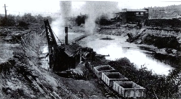
The Fremont Bridge was rebuilt several times. As the stream was widened to improve access for boat traffic, the elevation of the bridge had to be increased until its span reached North 34th Street as it does today. During the ship canal construction in 1914 the bridge was washed out by a dam break. A temporary Stone Way bridge was built to use until the ship canal was finished.
Upon completion of the Lake Washington Ship Canal project, the present bascule Fremont Bridge opened to traffic on June 15, 1917. This rebuilding included capacity for auto traffic in addition to streetcar tracks. The streetcar era in Seattle ended in 1941 but today, cars, buses, pedestrians and bicycles cross over the Fremont Bridge.
The Fremont Bridge was designated as a City of Seattle Historic Landmark in 1980, as characterized by its prominence of spatial location and its easily identifiable visual feature of the neighborhood. The Bridge contributes to the distinctive identity of Fremont.
Sources:
Leslie F. Blanchard, Street Railway Era in Seattle: A Chronicle of Six Decades, 1968.
Caroline Tobin, Fremont Historic Context Statement, 2009.
$40,000 Loss from Bursting Fremont Dam.” Seattle Daily Times, March 14, 1914, pages 1, 5, and 12.
“Building permits, Carl Signor, 2944 Westlake Avenue, build two-story frame store building.” Seattle Daily Times, August 18, 1904, page 7.
“Dam bursts on Lake Union… March 13, 1914.” HistoryLink Essay #20222 by David B. Williams, 2016.
Fremont Bridge — National Register of Historic Places.
Seattle Municipal Archives, photo number 2787, Signor grocery building.
“Wood trestle spans canal and connects Seattle’s Fremont neighborhood with the foot of Queen Anne Hill in 1892.” HistoryLink Essay #3309 by Priscilla Long.
“Fremont Bridge.” HistoryLink Essay #20374 by Glenn Drosendahl. This essay gives the timeline of the series of bridges which were built at Fremont, culminating in the present bridge.